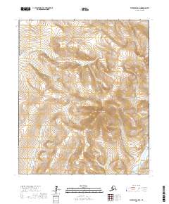
2017 Map of Bendeleben A-5 NE
USGS Topo · Published 2017About this map
Mt Bendeleben dominates the central landscape of this portion of the Seward Peninsula, marking the high point of the Bendeleben Mountains. This 2017 survey by the U.S. Geological Survey traces the high-altitude drainage patterns that define this subarctic environment, where the headwaters of the Niukluk River and Libby River descend from steep slopes into the surrounding valleys. The terrain is characterized by intense topographic relief, with the Belt Cr cutting through the northern sections of the map. This area is defined by its lack of permanent modern infrastructure, emphasizing a landscape shaped by natural processes and geological time. The survey provides a clear view of the mountain range's structure, reflecting the remote character of the Nome Census Area and the physical barriers that historically influenced travel and exploration in the Alaskan interior.
Find a feature on this map
10 named features on this map. Tap any name to fly to it.
Don’t see what you’re looking for? This feature index may not catch every label — zoom into the map to look around manually.
Map Details
Editions of this 2017 Bendeleben A-5 NE Map
This is the sole edition of this map. No revisions or reprints were ever made.
Other maps of this area

1950 · Bendeleben B-5
USGS Topo · 1:63,360

1950 · Bendeleben A-4
USGS Topo · 1:63,360

1950 · Bendeleben A-5
USGS Topo · 1:63,360

1950 · Bendeleben B-4
USGS Topo · 1:63,360

1950 · Bendeleben
USGS Topo · 1:250,000

1951 · Bendeleben
USGS Topo · 1:250,000

1964 · Bendeleben
USGS Topo · 1:250,000

1970 · Bendeleben A-4
USGS Topo · 1:63,360
2017 · Bendeleben B-5 SW
USGS Topo · 1:25,000
2017 · Bendeleben A-5 SW
USGS Topo · 1:25,000