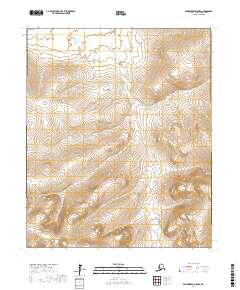
2017 Map of Bendeleben A-5 NW
USGS Topo · Published 2017About this map
The Seward Peninsula landscape dominates this section of the Nome Census Area, characterized by high-altitude topography and sparse nomenclature. The region is defined primarily by its hydrological patterns, specifically Belt Creek, which winds through the northern terrain. This data, compiled from various sources including the National Hydrography Dataset and the Bureau of Land Management, highlights the administrative organization of the Alaskan interior via the Public Land Survey System. The map documents the vast, unnamed peaks and valleys within the t3s r28w, t3s r27w, t4s r28w, and t4s r27w townships, where the absence of roads or established settlements underscores the wild character of the territory in the early twenty-first century.
Find a feature on this map
6 named features on this map. Tap any name to fly to it.
Don’t see what you’re looking for? This feature index may not catch every label — zoom into the map to look around manually.
Map Details
Editions of this 2017 Bendeleben A-5 NW Map
This is the sole edition of this map. No revisions or reprints were ever made.
Other maps of this area

1950 · Bendeleben A-6
USGS Topo · 1:63,360

1950 · Bendeleben B-5
USGS Topo · 1:63,360

1950 · Bendeleben B-6
USGS Topo · 1:63,360

1950 · Bendeleben A-5
USGS Topo · 1:63,360

1950 · Bendeleben
USGS Topo · 1:250,000

1951 · Bendeleben
USGS Topo · 1:250,000

1964 · Bendeleben
USGS Topo · 1:250,000
2017 · Bendeleben A-5 NE
USGS Topo · 1:25,000
2017 · Bendeleben B-5 SW
USGS Topo · 1:25,000
2017 · Bendeleben A-5 SW
USGS Topo · 1:25,000