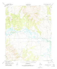
1950 Map of Bendeleben B-1
USGS Topo · Published 1975About this map
Kiwalik Mountain dominates the northern uplands of this Seward Peninsula landscape, where the Continental Divide winds through the terrain. The drainage network is defined by the Koyuk River and the Tubutulik River, illustrating the complex hydrology of the region in the mid-20th century. Evidence of human presence and movement is marked by the Winter Trail cutting across the eastern portion of the sheet. Of particular interest to researchers is the Last Chance (Site) near First Chance Creek, indicating a specific point of historical activity. Smaller tributaries like Goose Creek, Boomer Creek, and Big Bar Creek offer fine-grained detail for those studying the area's geography before significant modern changes.
Find a feature on this map
13 named features on this map. Tap any name to fly to it.
Don’t see what you’re looking for? This feature index may not catch every label — zoom into the map to look around manually.
Map Details
Editions of this 1950 Bendeleben B-1 Map
2 editions found
Other maps of this area

1950 · Bendeleben C-1
USGS Topo · 1:63,360

1950 · Bendeleben B-2
USGS Topo · 1:63,360

1950 · Bendeleben C-2
USGS Topo · 1:63,360

1950 · Bendeleben B-1
USGS Topo · 1:63,360

1950 · Bendeleben A-2
USGS Topo · 1:63,360

1950 · Bendeleben A-1
USGS Topo · 1:63,360

1950 · Bendeleben
USGS Topo · 1:250,000

1950 · Candle A-6
USGS Topo · 1:63,360

1950 · Candle B-6
USGS Topo · 1:63,360

1950 · Candle C-6
USGS Topo · 1:63,360