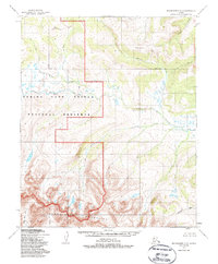
1950 Map of Bendeleben B-2
USGS Topo · Published 1987About this map
The Continental Divide winds through this subarctic landscape, separating the intricate drainage networks that feed the surrounding Seward Peninsula coast. To the south, the massive granite uplift of the Bendeleben Mountains anchors the terrain, giving rise to headwaters like the Tubutulik River. Much of the central and western portion of the sheet is protected within the Bering Land Bridge National Preserve, a wilderness area established to preserve the remnants of the ancient land bridge that once connected Asia and North America. The map reveals a land defined by water and elevation rather than human settlement, where the meandering Koyuk River and smaller tributaries like French Creek and Knowles Creek carve through the tundra. These waterways served as the primary transit corridors for indigenous hunters and early prospectors in an era when no roads or trails were yet established across this interior.
Find a feature on this map
14 named features on this map. Tap any name to fly to it.
Don’t see what you’re looking for? This feature index may not catch every label — zoom into the map to look around manually.
Map Details
Editions of this 1950 Bendeleben B-2 Map
3 editions found
Other maps of this area

1950 · Bendeleben C-1
USGS Topo · 1:63,360

1950 · Bendeleben C-3
USGS Topo · 1:63,360

1950 · Bendeleben B-2
USGS Topo · 1:63,360

1950 · Bendeleben A-3
USGS Topo · 1:63,360

1950 · Bendeleben C-2
USGS Topo · 1:63,360

1950 · Bendeleben B-1
USGS Topo · 1:63,360

1950 · Bendeleben A-2
USGS Topo · 1:63,360

1950 · Bendeleben A-1
USGS Topo · 1:63,360

1950 · Bendeleben B-3
USGS Topo · 1:63,360

1950 · Bendeleben
USGS Topo · 1:250,000