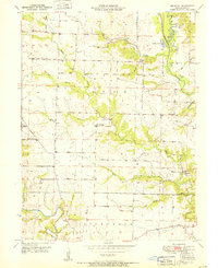
1951 Map of Benjamin
USGS Topo · Published 1951About this map
The North Fabius River and Wyaconda River define the undulating landscape of northeastern Missouri, framing a rural community at the start of the 1950s. This survey by Edward L. Clark reveals a dense network of local landmarks essential to mid-century rural life in Lewis County. While the settlement of Benjamin remains a focal point, the map documents numerous disappearing rural centers including Derrahs and several family-named locations. The distribution of Zion Hill Ch and Antioch Ch alongside burial grounds like Graves Cem and Patterson Cem illustrates the deep-rooted community structure of the time. The landscape is also dotted with neighborhood education centers such as Allen Sch, Bunker Hill Sch, and Plano Sch, showing how schooling was geographically dispersed across the townships of Lyon and Dickerson before the widespread consolidation of rural districts.
Find a feature on this map
26 named features on this map. Tap any name to fly to it.
Don’t see what you’re looking for? This feature index may not catch every label — zoom into the map to look around manually.
Map Details
Editions of this 1951 Benjamin Map
2 editions found
Other maps of this area

1903 · Kahoka
USGS Topo · 1:125,000

1949 · Kahoka SE
USGS Topo · 1:24,000

1949 · St. Patrick
USGS Topo · 1:24,000

1950 · Saint Patrick
USGS Topo · 1:24,000

1950 · Kahoka SE
USGS Topo · 1:24,000

1950 · Neeper
USGS Topo · 1:24,000

1950 · La Grange
USGS Topo · 1:24,000

1950 · Benjamin
USGS Topo · 1:24,000

1950 · Williamstown
USGS Topo · 1:24,000

1950 · Canton
USGS Topo · 1:24,000