1949 Map of Benndale
USGS Topo · Published 1949About this map
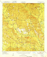
De Soto National Forest dominates the landscape of southern Mississippi in the late 1940s, a period when the timber and turpentine industries shaped the local economy. This survey documents a rural network of small communities and family landmarks, such as the Benndale post office and the healing waters of Ramsey Springs. The map reveals the intricate drainage system of the Black Creek and Red Creek watersheds, which are crossed by vital historic spans like Alexander Bridge and Parker Bridge. Genealogists will find significant value in the numerous family cemeteries and country churches scattered through the pines, including Hatten Cem, Whittington Cem, and Sweetwater Ch. Educational life in this era is represented by local institutions like Holly Grove Sch and Broome Sch, while fire lookouts like Wilbe Fire Tower stand watch over the forested hills.
Find a feature on this map
84 named features on this map. Tap any name to fly to it.
Don’t see what you’re looking for? This feature index may not catch every label — zoom into the map to look around manually.
Map Details
Editions of this 1949 Benndale Map
2 editions found

Other maps of this area

1941 · Vancleave
USGS Topo · 1:62,500

1941 · Lucedale
USGS Topo · 1:62,500

1943 · Lucedale
USGS Topo · 1:62,500

1943 · Vancleave
USGS Topo · 1:62,500

1944 · Vancleave
USGS Topo · 1:62,500

1947 · Beaumont
USGS Topo · 1:62,500

1947 · Wiggins
USGS Topo · 1:62,500

1947 · New Augusta
USGS Topo · 1:62,500

1947 · Benndale
USGS Topo · 1:62,500

1949 · Wiggins
USGS Topo · 1:62,500