
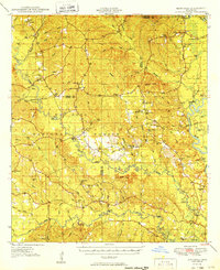
1949 Map of Benndale
USGS Topo · Published 1949About this map
The winding Pascagoula River and Black Creek define the geography of this 1940s landscape, where the De Soto National Forest blankets the intersections of George, Greene, Perry, and Stone counties. The post office at Benndale serves as a central hub for a community rooted in the timber-rich hills, including Ramsey Springs and Barbara. This survey documents a rural network of family-named landmarks and local institutions, such as St Luke Ch, Mars Hill Ch, and the Salem Sch, which once anchored these remote settlements before the modern expansion of highway infrastructure.
Find a feature on this map
71 named features on this map. Tap any name to fly to it.
Don’t see what you’re looking for? This feature index may not catch every label — zoom into the map to look around manually.
Map Details
Editions of this 1949 Benndale Map
2 editions found
Other maps of this area

1941 · Vancleave
USGS Topo · 1:62,500

1941 · Lucedale
USGS Topo · 1:62,500

1943 · Lucedale
USGS Topo · 1:62,500

1943 · Vancleave
USGS Topo · 1:62,500

1944 · Vancleave
USGS Topo · 1:62,500

1947 · Beaumont
USGS Topo · 1:62,500

1947 · Wiggins
USGS Topo · 1:62,500

1947 · New Augusta
USGS Topo · 1:62,500

1947 · Benndale
USGS Topo · 1:62,500

1949 · Wiggins
USGS Topo · 1:62,500