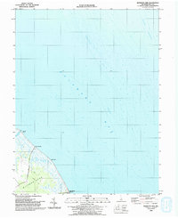
1993 Map of Bennetts Pier
USGS Topo · Published 1993About this map
Milford Neck dominates the terrestrial landscape of this coastal survey, where the marshes of Kent County meet the vast waters of Delaware Bay. The map highlights a remote stretch of shoreline defined by small maritime outposts like Bennetts Pier and Big Stone Beach, both connected to the interior by simple 4wd tracks and Bennetts Pier Road. A Lookout Tower stands near the southern edge of the sheet, likely serving as a sentinel over the tidal flats and the intricate network of waterways like Brockonbridge Gut. Offshore, the survey provides significant hydrographic detail, mapping the underwater topography of Blake Channel and the specific depths of Cedarbrush Hole and Hawknest. This nautical focus reveals the submerged hazards and navigable paths essential for the local fishing and boating economy during the early 1990s.
Find a feature on this map
13 named features on this map. Tap any name to fly to it.
Don’t see what you’re looking for? This feature index may not catch every label — zoom into the map to look around manually.
Map Details
Editions of this 1993 Bennetts Pier Map
This is the sole edition of this map. No revisions or reprints were ever made.
Other maps of this area

1890 · Maurice Cove
USGS Topo · 1:62,500

1891 · Maurice Cove
USGS Topo · 1:62,500

1899 · Vineland
USGS Topo · 1:125,000

1918 · Cedar Creek
USGS Topo · 1:62,500

1918 · Cape Henlopen
USGS Topo · 1:62,500

1919 · Cedar Creek
USGS Topo · 1:62,500

1919 · Vineland
USGS Topo · 1:125,000

1934 · Bowers
USGS Topo · 1:48,000
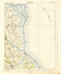
1936 · Bowers
USGS Topo · 1:62,500

1937 · Cape Henlopen
USGS Topo · 1:62,500