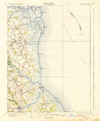
1936 Map of Bowers
USGS Topo · Published 1936About this map
The salt marshes and tidal guts of Kent County define this coastal landscape during the mid-1930s, where the Leipsic River and St Jones River meander toward the Delaware Bay. Inland, the terrain is shaped by agricultural districts and small, established settlements like Frederica and Magnolia. This survey captures a network of rural schoolhouses and country churches that anchored the community, including Barretts Chapel and the Friends Meetinghouse. Navigation remains vital to the local economy, as evidenced by the Mahon River L H and the offshore Elbow of Cross Ledge L H. The map illustrates the transition from river-dependent sites like Barkers Landing to beach-side locations such as Pickering Beach and Kitts Hummock, all while U S Highway No 113 began to modernize regional travel.
Find a feature on this map
56 named features on this map. Tap any name to fly to it.
Don’t see what you’re looking for? This feature index may not catch every label — zoom into the map to look around manually.
Map Details
Editions of this 1936 Bowers Map
4 editions found
Other maps of this area

1890 · Maurice Cove
USGS Topo · 1:62,500

1890 · Bay Side
USGS Topo · 1:62,500

1890 · Bridgeton
USGS Topo · 1:62,500

1891 · Maurice Cove
USGS Topo · 1:62,500

1894 · Bay Side
USGS Topo · 1:62,500

1894 · Bridgeton
USGS Topo · 1:62,500

1899 · Vineland
USGS Topo · 1:125,000

1899 · Dover
USGS Topo · 1:125,000

1906 · Dover
USGS Topo · 1:125,000

1918 · Cedar Creek
USGS Topo · 1:62,500