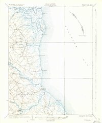
1936 Map of Bowers
USGS Topo · Published 1936About this map
St Jones Neck and Murderkill Neck dominate this mid-1930s coastal landscape, where the marshy Delaware shoreline is defined by intricate tidal guts and the sweep of the Delaware Bay. The survey illustrates a rural economy transitioning into the modern era, with U S Highway 113 bypassing older riverfront settlements like Barkers Landing. Historic religious life is well-documented through landmarks such as the Friends Meetinghouse and Barratts Chapel, while the maritime importance of the region is anchored by the Mahon River L H and the offshore Elbow of Cross Ledge L H.
Find a feature on this map
60 named features on this map. Tap any name to fly to it.
Don’t see what you’re looking for? This feature index may not catch every label — zoom into the map to look around manually.
Map Details
Editions of this 1936 Bowers Map
4 editions found
Other maps of this area

1890 · Maurice Cove
USGS Topo · 1:62,500

1890 · Bay Side
USGS Topo · 1:62,500

1890 · Bridgeton
USGS Topo · 1:62,500

1891 · Maurice Cove
USGS Topo · 1:62,500

1894 · Bay Side
USGS Topo · 1:62,500

1894 · Bridgeton
USGS Topo · 1:62,500

1899 · Vineland
USGS Topo · 1:125,000

1899 · Dover
USGS Topo · 1:125,000

1906 · Dover
USGS Topo · 1:125,000

1918 · Cedar Creek
USGS Topo · 1:62,500