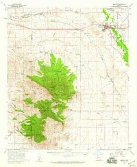
1958 Map of Benson
USGS Topo · Published 1959About this map
Benson serves as a critical junction for the Southern Pacific RR and U.S. Route 80, anchored by the flow of the San Pedro River to its east. This late 1950s survey captures the community as it expanded near Lake Iris, featuring infrastructure like the Benson Airport and a Drive-in Theater on the town's edge. To the north, agricultural developments follow the Pomerene Canal near the settlement of Pomerene, while the western landscape is dominated by the steep peaks of the Whetstone Mountains.
Find a feature on this map
90 named features on this map. Tap any name to fly to it.
Don’t see what you’re looking for? This feature index may not catch every label — zoom into the map to look around manually.
Map Details
Editions of this 1958 Benson Map
3 editions found
Other maps of this area

1904 · Patagonia
USGS Topo · 1:125,000

1904 · Tucson
USGS Topo · 1:125,000

1905 · Patagonia
USGS Topo · 1:125,000

1905 · Tucson
USGS Topo · 1:125,000

1915 · Benson
USGS Topo · 1:125,000

1922 · St. David
USGS Topo · 1:62,500

1926 · Whetstone
USGS Topo · 1:62,500

1932 · Fairbank
USGS Topo · 1:62,500

1932 · Elgin
USGS Topo · 1:62,500

1938 · Huachuca
USGS Topo · 1:62,500