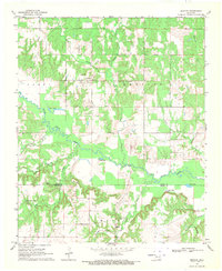
1969 Map of Bentley
USGS Topo · Published 1971About this map
Bentley sits at the intersection of rural roads north of the Atoka Co Bryan Co line, serving as a focal point for this landscape of meandering creeks and low-lying wetlands. The community is anchored by Caney Hill Ch and a nearby cemetery, while the southern settlement of Matoy is marked by the Matoy Cem. The area is defined by the winding course of Clear Boggy Creek and its numerous tributaries, including Cowpen Creek and Long Branch, which feed into several prominent water bodies such as Twin Lakes, Grassy Lake, and Clear Lake. This 1969 field-checked survey highlights a distinct local hydrography where small springs like Turnbull Springs and named branches like Dancing Rabbit Creek create a complex network of drainage across the county border. The map also records numerous unnamed structures and field lines, providing a detailed record of late 20th-century land use and habitation patterns in this corner of Oklahoma.
Find a feature on this map
25 named features on this map. Tap any name to fly to it.
Don’t see what you’re looking for? This feature index may not catch every label — zoom into the map to look around manually.
Map Details
Editions of this 1969 Bentley Map
2 editions found
Other maps of this area

1899 · Atoka
USGS Topo · 1:125,000

1900 · Atoka
USGS Topo · 1:125,000

1901 · Antlers
USGS Topo · 1:125,000

1912 · Antlers
USGS Topo · 1:125,000

1925 · Antlers
USGS Topo · 1:125,000

1950 · Mcalester
USGS Topo · 1:250,000

1957 · Bruno
USGS Topo · 1:24,000

1957 · Lane
USGS Topo · 1:24,000

1957 · Ardmore
USGS Topo · 1:250,000

1962 · McAlester
USGS Topo · 1:250,000