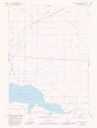
1951 Map of Benton Basin SW
USGS Topo · Published 1985About this map
Oregon Trail tracks cut across the northern section of this landscape, marking the historic westward migration route through the arid terrain of central Wyoming. This 1951 survey, with revisions from the 1980s, highlights the intersection of pioneer history and modern conservation efforts. The southern portion of the sheet is dominated by the Pathfinder Reservoir, which is surrounded by the Pathfinder National Wildlife Refuge. The hydrology is defined by seasonal watercourses such as Horse Creek and Fish Creek, which drain into the reservoir. Infrastructure is sparse but telling of the region's utility, including a Pipe Line and a localized Oil Tank. This map captures a specific transition in the Wyoming interior, where the heritage of the trail meets the large-scale water management and wildlife protection established in the twentieth century.
Find a feature on this map
12 named features on this map. Tap any name to fly to it.
Don’t see what you’re looking for? This feature index may not catch every label — zoom into the map to look around manually.
Map Details
Editions of this 1951 Benton Basin SW Map
3 editions found
Other maps of this area

1951 · Benton Basin SW
USGS Topo · 1:24,000

1951 · Benton Basin
USGS Topo · 1:24,000

1951 · Pathfinder Reservoir NW
USGS Topo · 1:24,000

1951 · Benton Basin NE
USGS Topo · 1:24,000

1951 · Mc Cleary Reservoir
USGS Topo · 1:24,000

1951 · Pathfinder Dam
USGS Topo · 1:24,000

1951 · Fort Ridge
USGS Topo · 1:24,000

1955 · Casper
USGS Topo · 1:250,000

1958 · Casper
USGS Topo · 1:250,000

1959 · Horse Creek Springs
USGS Topo · 1:24,000