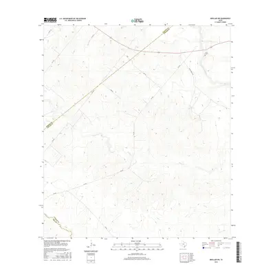
2016 Map of Berclair NW
USGS Topo · Published 2016About this map
The San Antonio River winds through the northeastern corner of this South Texas landscape, where the borders of Bee, Goliad, and Karnes counties converge. This 2016 survey documents a sparsely populated rural terrain dominated by a network of drainage systems, including Hord Cr, Lost Cr, and Live Oak Cr. The topography is defined by rolling contours and a web of secondary farm-to-market roads and local routes such as Mail Rd and Newton Powell Rd. The presence of the Charco Cem near the river provides a specific point of interest for genealogical research in this quiet ranching and agricultural region. While major settlements are absent, the map details the distinct naming conventions of local landmarks and roads like Rockhill and Ford Rd, reflecting the historical property lines and traditional transport paths that shaped the county line area.
Find a feature on this map
16 named features on this map. Tap any name to fly to it.
Don’t see what you’re looking for? This feature index may not catch every label — zoom into the map to look around manually.
Map Details
Editions of this 2016 Berclair NW Map
This is the sole edition of this map. No revisions or reprints were ever made.
Other maps of this area
1936 · Pettus
USGS Topo · 1:62,500
1953 · Beeville
USGS Topo · 1:250,000
1956 · Beeville
USGS Topo · 1:250,000
1956 · Pettus
USGS Topo · 1:62,500
1956 · Karnes City
USGS Topo · 1:62,500
1960 · Beeville
USGS Topo · 1:250,000
1961 · Kenedy
USGS Topo · 1:24,000
1963 · Tuleta
USGS Topo · 1:24,000
1963 · Tulsita
USGS Topo · 1:24,000
1963 · Choate
USGS Topo · 1:24,000