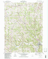
1994 Map of Bergholz
USGS Topo · Published 1998About this map
Bergholz and the surrounding townships of Washington, Fox, Lee, and Springfield define this eastern Ohio landscape during the late twentieth century. The map centers on the winding course of Yellow Creek and its many tributaries, such as Elkhorn Creek and Blazer Hollow, where the terrain transitions from agricultural uplands to deep-cut valleys. This topographic record preserves the locations of vital community centers including Harlem Springs and Mechanicstown, alongside several rural gathering points like Scroggsfield Ch and Springfield High Sch. Extensive Strip Mine operations are evident across several sections, particularly near the Jefferson and Carroll County border, illustrating the area's long-standing reliance on surface coal extraction. Genealogists will find significant value in the documentation of several burial grounds, from the Bergholz Cem to the smaller Palmer Cem and the Chestnut Ridge Ch Cem.
Find a feature on this map
33 named features on this map. Tap any name to fly to it.
Don’t see what you’re looking for? This feature index may not catch every label — zoom into the map to look around manually.
Map Details
Editions of this 1994 Bergholz Map
This is the sole edition of this map. No revisions or reprints were ever made.
Other maps of this area

1901 · Cadiz
USGS Topo · 1:62,500

1902 · Scio
USGS Topo · 1:62,500

1903 · Cadiz
USGS Topo · 1:62,500

1904 · Scio
USGS Topo · 1:62,500

1905 · Salineville
USGS Topo · 1:62,500

1910 · Carrollton
USGS Topo · 1:62,500

1912 · Carrollton
USGS Topo · 1:62,500

1951 · Canton
USGS Topo · 1:250,000

1953 · Canton
USGS Topo · 1:250,000

1957 · Canton
USGS Topo · 1:250,000