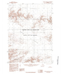
1985 Map of Bering Glacier B-3
USGS Topo · Published 1985About this map
Bagley Icefield dominates the northern expanse of this 1980s Alaskan survey, where massive ice flows and high-altitude terrain define the landscape. This region of the Wrangell-Saint Elias National Park is characterized by its dynamic glacial movements, including the prominent Yahtse Glacier which carves through the central terrain. To the south, the Robinson Mountains rise sharply, anchored by landmarks like Mount Leeper and Barkley Ridge. The map preserves a moment when much of this territory was designated as the Wrangell-Saint Elias Wilderness, reflecting a period of rigorous federal land management and preservation. Topographic contours reveal the complex elevations of the ice fields and nunataks, providing a window into the state of these glacial systems as they were documented through early 1970s aerial photography.
Find a feature on this map
8 named features on this map. Tap any name to fly to it.
Don’t see what you’re looking for? This feature index may not catch every label — zoom into the map to look around manually.
Map Details
Editions of this 1985 Bering Glacier B-3 Map
This is the sole edition of this map. No revisions or reprints were ever made.
Other maps of this area

1948 · Bering Glacier A-4
USGS Topo · 1:63,360

1950 · Bering Glacier A-3
USGS Topo · 1:63,360

1950 · Bering Glacier
USGS Topo · 1:250,000

1951 · Bering Glacier
USGS Topo · 1:250,000
1951 · Bering Glacier A-4
USGS Topo · 1:63,360

1951 · Bering Glacier A-2
USGS Topo · 1:63,360

1959 · Bering Glacier
USGS Topo · 1:250,000
1959 · Bering Glacier A-3
USGS Topo · 1:63,360
1959 · Bering Glacier A-4
USGS Topo · 1:63,360

1959 · Bering Glacier A-2
USGS Topo · 1:63,360