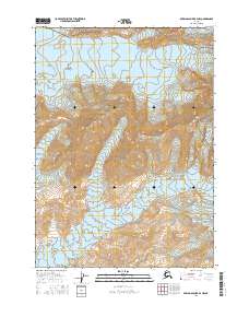
2016 Map of Bering Glacier B-4 NW
USGS Topo · Published 2016About this map
Wrangell-Saint Elias National Park encompasses the majority of this Alaskan wilderness, where massive ice fields dominate the high-altitude landscape. The Bering Glacier flows through the central and western portions of the quadrangle, representing a significant portion of the largest glacier in North America. To the east, the Yahtse Glacier makes a notable appearance, further illustrating the frozen, high-relief environment. High peaks and dividers such as Mt Miller and Barkley Ridge rise between these moving ice masses, defining the drainages and flow patterns of the region. This 2016 survey documents the extent of these glaciers and the complex topography of the coastal mountains within the protected federal parklands.
Find a feature on this map
11 named features on this map. Tap any name to fly to it.
Don’t see what you’re looking for? This feature index may not catch every label — zoom into the map to look around manually.
Map Details
Editions of this 2016 Bering Glacier B-4 NW Map
This is the sole edition of this map. No revisions or reprints were ever made.
Other maps of this area

1950 · Bering Glacier
USGS Topo · 1:250,000

1951 · Bering Glacier
USGS Topo · 1:250,000

1959 · Bering Glacier
USGS Topo · 1:250,000
1985 · Bering Glacier B-5
USGS Topo · 1:63,360
1985 · Bering Glacier C-5
USGS Topo · 1:63,360
1985 · Bering Glacier B-4
USGS Topo · 1:63,360
1985 · Bering Glacier C-4
USGS Topo · 1:63,360
2016 · Bering Glacier B-5 NE
USGS Topo · 1:25,000
2016 · Bering Glacier C-4 SE
USGS Topo · 1:25,000
2016 · Bering Glacier B-4 SW
USGS Topo · 1:25,000