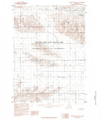
1985 Map of Bering Glacier C-5
USGS Topo · Published 1985About this map
The vast expanse of the Bagley Icefield dominates the southern reaches of this landscape, its frozen surface part of a massive glacial system within the Wrangell-Saint Elias National Park. This mid-1980s provisional survey documents a high-altitude wilderness where ice is the primary architect of the terrain. The Tana Glacier flows through the central portion of the map, flanked by the prominent Thompson Ridge. Rare open water appears at the edges of the ice, including Barkley Lake and Ross Green Lake. This sheet reflects the protected status of the area under the Wrangell-Saint Elias Wilderness designation, showing a landscape defined by natural forces rather than human infrastructure, as the road legend confirms no roads or trails were present in the area at the time of publication.
Find a feature on this map
12 named features on this map. Tap any name to fly to it.
Don’t see what you’re looking for? This feature index may not catch every label — zoom into the map to look around manually.
Map Details
Editions of this 1985 Bering Glacier C-5 Map
This is the sole edition of this map. No revisions or reprints were ever made.
Other maps of this area

1950 · Bering Glacier
USGS Topo · 1:250,000

1951 · Bering Glacier
USGS Topo · 1:250,000

1959 · Bering Glacier
USGS Topo · 1:250,000

1984 · Bering Glacier D-4
USGS Topo · 1:63,360
1984 · Bering Glacier D-6
USGS Topo · 1:63,360

1984 · Bering Glacier D-5
USGS Topo · 1:63,360
1985 · Bering Glacier B-5
USGS Topo · 1:63,360
1985 · Bering Glacier B-6
USGS Topo · 1:63,360
1985 · Bering Glacier B-4
USGS Topo · 1:63,360
1985 · Bering Glacier C-4
USGS Topo · 1:63,360