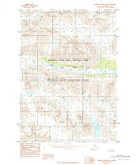
1984 Map of Bering Glacier D-6
USGS Topo · Published 1984About this map
Wrangell - Saint Elias National Park and the adjacent Wrangell - Saint Elias Wilderness dominate this Alaskan landscape as it was documented in the early 1980s. The map illustrates a high-altitude wilderness defined by massive glacial systems, notably the Bremner Glacier and the Tana Lobe. These icy expanses feed into the valley of the West Fork Tana River, which cuts across the central portion of the quadrangle. The terrain is characterized by steep elevation changes and a total absence of man-made infrastructure, reflecting the territory's status as a protected wilderness area. This 1984 provisional edition, based on 1972 aerial photography, provides a precise look at the glacial margins and drainage patterns before modern climate shifts altered these ice fields.
Find a feature on this map
10 named features on this map. Tap any name to fly to it.
Don’t see what you’re looking for? This feature index may not catch every label — zoom into the map to look around manually.
Map Details
Editions of this 1984 Bering Glacier D-6 Map
2 editions found
Other maps of this area

1950 · Bering Glacier
USGS Topo · 1:250,000

1951 · McCarthy
USGS Topo · 1:250,000

1951 · Bering Glacier
USGS Topo · 1:250,000

1959 · McCarthy A-5
USGS Topo · 1:63,360

1959 · McCarthy A-6
USGS Topo · 1:63,360

1959 · Bering Glacier
USGS Topo · 1:250,000

1959 · McCarthy A-7
USGS Topo · 1:63,360

1960 · McCarthy
USGS Topo · 1:250,000
1984 · Bering Glacier D-7
USGS Topo · 1:63,360

1984 · Bering Glacier D-5
USGS Topo · 1:63,360