
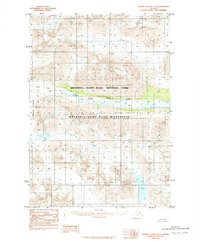
1984 Map of Bering Glacier D-5
USGS Topo · Published 1984About this map
Tana River and its braided channels dominate this glacially carved landscape, illustrating the dynamic hydrological systems within the Wrangell - Saint Elias National Park. The map provides a detailed view of the transition from the Tana Glacier terminus into the river valley, where sediment-rich waters flow through wide gravel flats. High peaks of the Granite Range rise to the east, their slopes etched with seasonal drainage like Twelvemile Creek. Compiled from 1972 aerial photography, this provisional survey documents the wilderness area before modern shifts in glacial geography, capturing the intricate network of the West Fork and the expansive glacial moraines that define this subarctic environment. The lack of roads or established trails on the map emphasizes the primitive state of the Wrangell - Saint Elias Wilderness during the mid-1980s.
Find a feature on this map
7 named features on this map. Tap any name to fly to it.
Don’t see what you’re looking for? This feature index may not catch every label — zoom into the map to look around manually.
Map Details
Editions of this 1984 Bering Glacier D-5 Map
This is the sole edition of this map. No revisions or reprints were ever made.
Other maps of this area

1950 · Bering Glacier
USGS Topo · 1:250,000

1951 · McCarthy
USGS Topo · 1:250,000

1951 · Bering Glacier
USGS Topo · 1:250,000

1959 · McCarthy A-4
USGS Topo · 1:63,360

1959 · McCarthy A-5
USGS Topo · 1:63,360

1959 · McCarthy A-6
USGS Topo · 1:63,360

1959 · Bering Glacier
USGS Topo · 1:250,000

1960 · McCarthy
USGS Topo · 1:250,000

1984 · Bering Glacier D-4
USGS Topo · 1:63,360
1984 · Bering Glacier D-6
USGS Topo · 1:63,360