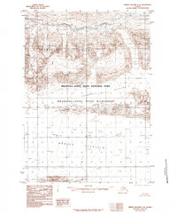
1985 Map of Bering Glacier C-4
USGS Topo · Published 1985About this map
Bagley Icefield dominates the southern reaches of this 1985 survey, illustrating the immense glacial systems that define the Chugach Mountains near the Gulf of Alaska coast. This high-altitude plateau of ice feeds into the surrounding Wrangell-Saint Elias National Park, a protected landscape of massive ice flows and sharp rock outcroppings. Central to the map is the prominent Thompson Ridge, which divides the glacial fields and leads toward the heights of Needle Mountain. In the northern section, the terrain breaks into the turbulent Granite Rapids and the sheltered Ross Green Lakes, showing the transition from ice-locked summits to the raw hydrology of the subarctic. The inclusion of the Wrangell Saint Elias Wilderness designation underscores the region's status as a primitive, roadless frontier where features like Juniper Island and Jefferies emerge from the shifting moraine and ice.
Find a feature on this map
12 named features on this map. Tap any name to fly to it.
Don’t see what you’re looking for? This feature index may not catch every label — zoom into the map to look around manually.
Map Details
Editions of this 1985 Bering Glacier C-4 Map
This is the sole edition of this map. No revisions or reprints were ever made.
Other maps of this area

1950 · Bering Glacier
USGS Topo · 1:250,000

1951 · Bering Glacier
USGS Topo · 1:250,000

1959 · Bering Glacier
USGS Topo · 1:250,000

1984 · Bering Glacier D-4
USGS Topo · 1:63,360

1984 · Bering Glacier D-5
USGS Topo · 1:63,360
1984 · Bering Glacier D-3
USGS Topo · 1:63,360
1985 · Bering Glacier B-5
USGS Topo · 1:63,360
1985 · Bering Glacier C-5
USGS Topo · 1:63,360
1985 · Bering Glacier B-4
USGS Topo · 1:63,360
1985 · Bering Glacier B-3
USGS Topo · 1:63,360