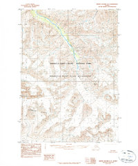
1984 Map of Bering Glacier D-3
USGS Topo · Published 1984About this map
Wrangell-Saint Elias National Park dominates this high-altitude landscape in southeastern Alaska, as documented in a provisional survey compiled from 1972 aerial photography. The terrain is defined by the sharp elevations of the Granite Range and the prominent peak of Mount Gage, which rises over 8,000 feet. Drainage through this ice-carved environment is primarily represented by Goat Creek, which cuts through the northeastern portion of the quadrangle. The map highlights the designated Wrangell-Saint Elias Wilderness areas, emphasizing the remote and undeveloped character of the region during the late twentieth century. This sheet captures a frozen landscape of unnamed glaciers and high peaks before significant modern shifts in ice coverage, serving as a baseline for the geography of one of America's most expansive wilderness preserves.
Find a feature on this map
5 named features on this map. Tap any name to fly to it.
Don’t see what you’re looking for? This feature index may not catch every label — zoom into the map to look around manually.
Map Details
Editions of this 1984 Bering Glacier D-3 Map
2 editions found
Other maps of this area

1950 · Bering Glacier
USGS Topo · 1:250,000

1951 · McCarthy
USGS Topo · 1:250,000

1951 · Bering Glacier
USGS Topo · 1:250,000

1959 · McCarthy A-4
USGS Topo · 1:63,360

1959 · McCarthy A-2
USGS Topo · 1:63,360

1959 · McCarthy A-3
USGS Topo · 1:63,360

1959 · Bering Glacier
USGS Topo · 1:250,000

1960 · McCarthy
USGS Topo · 1:250,000
1984 · Bering Glacier D-2
USGS Topo · 1:63,360

1984 · Bering Glacier D-4
USGS Topo · 1:63,360