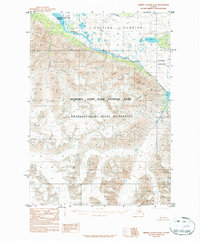
1984 Map of Bering Glacier D-2
USGS Topo · Published 1984About this map
Chitina River serves as the dominant hydrological artery in this subarctic wilderness, carving through a landscape defined by massive ice fields and steep drainages. In the mid-1980s, this region was undergoing a significant shift in administrative oversight following the passage of the Alaska National Interest Lands Conservation Act. This transition is evident in the overlapping designations of the Wrangell-Saint Elias National Park, the Wrangell-Saint Elias Wilderness, and the Wrangell-Saint Elias Preserve, which together create a massive protected corridor for glacial systems. The topography is anchored by the Chitina Glacier and the Logan Glacier, whose meltwaters feed the complex river network. Marble Creek provides one of the few named terrestrial markers in a territory largely defined by ice and rock, illustrating the scale of the glacier-driven ecosystem.
Find a feature on this map
7 named features on this map. Tap any name to fly to it.
Don’t see what you’re looking for? This feature index may not catch every label — zoom into the map to look around manually.
Map Details
Editions of this 1984 Bering Glacier D-2 Map
This is the sole edition of this map. No revisions or reprints were ever made.
Other maps of this area

1950 · Bering Glacier
USGS Topo · 1:250,000

1951 · McCarthy
USGS Topo · 1:250,000

1951 · Bering Glacier
USGS Topo · 1:250,000

1959 · McCarthy A-2
USGS Topo · 1:63,360

1959 · McCarthy A-3
USGS Topo · 1:63,360
1959 · McCarthy A-1
USGS Topo · 1:63,360

1959 · Bering Glacier
USGS Topo · 1:250,000

1960 · McCarthy
USGS Topo · 1:250,000
1984 · Bering Glacier D-1
USGS Topo · 1:63,360
1984 · Bering Glacier D-3
USGS Topo · 1:63,360