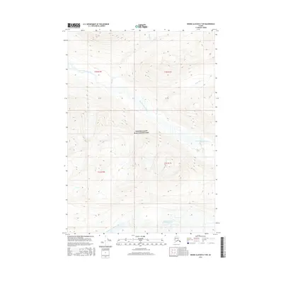
2016 Map of Bering Glacier D-7 NW
USGS Topo · Published 2016About this map
Wrangell-Saint Elias National Park encompasses this high-altitude Alaskan wilderness, where massive glacial flows and mountain drainages define the landscape. The south-central portion of the map is dominated by the Middle Fork Lobe Bremner Glacier, a significant ice feature that feeds the surrounding watershed. The intricate drainage network includes the North Fork Bremner River and the Middle Fork Bremner River, which carve through steep elevation contours and receive runoff from numerous alpine tributaries like Golconda Cr and Ptarmigan Cr. This 2016 survey illustrates the pristine hydrology and glacial margins of the Copper River basin, offering a detailed record of ice extent and river morphology in a protected wilderness area that remains free of roads or human settlements.
Find a feature on this map
11 named features on this map. Tap any name to fly to it.
Don’t see what you’re looking for? This feature index may not catch every label — zoom into the map to look around manually.
Map Details
Editions of this 2016 Bering Glacier D-7 NW Map
This is the sole edition of this map. No revisions or reprints were ever made.
Other maps of this area

1950 · McCarthy A-8
USGS Topo · 1:63,360

1950 · Bering Glacier
USGS Topo · 1:250,000

1951 · McCarthy
USGS Topo · 1:250,000

1951 · Bering Glacier
USGS Topo · 1:250,000

1959 · Bering Glacier
USGS Topo · 1:250,000

1959 · McCarthy A-7
USGS Topo · 1:63,360

1960 · McCarthy
USGS Topo · 1:250,000
1984 · Bering Glacier D-7
USGS Topo · 1:63,360
1984 · Bering Glacier D-8
USGS Topo · 1:63,360
2014 · Bering Glacier D-7 NE
USGS Topo · 1:25,000