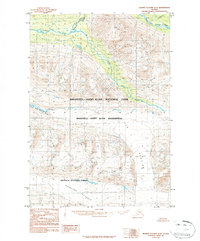
1984 Map of Bering Glacier D-8
USGS Topo · Published 1984About this map
Bremner River and its intricate drainage system dominate this 1984 survey of the Alaskan interior. This provisional map illustrates a landscape shaped by massive ice movements, featuring the expansive Fan Glacier and Wernicke Glacier. The convergence of the North Fork and South Fork Bremner River highlights the complex hydrology of this high-altitude environment. Administrative boundaries are clearly marked, showing where the Wrangell - Saint Elias National Park meets the Chugach National Forest. The presence of Twelvemile Canyon and the Middle Fork tributary underscores the erosive power of glacial meltwater in this protected wilderness area. Compiled from 1972 aerial photography, this map serves as a primary record of glacial positioning and terrain before further modern environmental shifts.
Find a feature on this map
11 named features on this map. Tap any name to fly to it.
Don’t see what you’re looking for? This feature index may not catch every label — zoom into the map to look around manually.
Map Details
Editions of this 1984 Bering Glacier D-8 Map
2 editions found
Other maps of this area

1948 · Cordova
USGS Topo · 1:250,000

1950 · McCarthy A-8
USGS Topo · 1:63,360

1950 · Bering Glacier
USGS Topo · 1:250,000

1951 · McCarthy
USGS Topo · 1:250,000

1951 · Bering Glacier
USGS Topo · 1:250,000

1951 · Cordova
USGS Topo · 1:250,000

1951 · Valdez A-1
USGS Topo · 1:63,360

1952 · Valdez
USGS Topo · 1:250,000

1959 · Cordova D-1
USGS Topo · 1:63,360

1959 · Cordova C-1
USGS Topo · 1:63,360