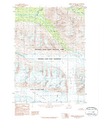
1984 Map of Bering Glacier D-8
USGS Topo · Published 1987About this map
The Bremner River watershed dominates this mid-1980s Alaskan survey, where glacial movement and high mountain drainage define the boundary between protected federal lands. The landscape is split between the northern reaches of the Chugach National Forest and the vast Wrangell - Saint Elias National Park, including the dedicated Wrangell - Saint Elias Wilderness zone. Dramatic elevation changes are evidenced by the sheer descent into Twelvemile Canyon and the confluence of the North Fork and South Fork Bremner River. Large ice masses, most notably the Wernicke Glacier and the distinctively named Fan Glacier, carve through the terrain, illustrating the active geomorphology of the Copper River Meridian region. The map captures a moment in the management of these territories shortly after the establishment of the current national park boundaries.
Find a feature on this map
19 named features on this map. Tap any name to fly to it.
Don’t see what you’re looking for? This feature index may not catch every label — zoom into the map to look around manually.
Map Details
Editions of this 1984 Bering Glacier D-8 Map
2 editions found
Other maps of this area

1948 · Cordova
USGS Topo · 1:250,000

1950 · McCarthy A-8
USGS Topo · 1:63,360

1950 · Bering Glacier
USGS Topo · 1:250,000

1951 · McCarthy
USGS Topo · 1:250,000

1951 · Bering Glacier
USGS Topo · 1:250,000

1951 · Cordova
USGS Topo · 1:250,000

1951 · Valdez A-1
USGS Topo · 1:63,360

1952 · Valdez
USGS Topo · 1:250,000

1959 · Cordova D-1
USGS Topo · 1:63,360

1959 · Cordova C-1
USGS Topo · 1:63,360