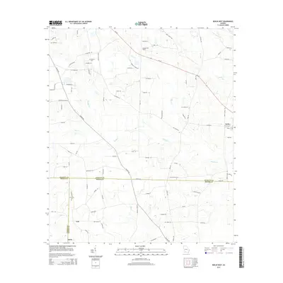
2014 Map of Berlin West
USGS Topo · Published 2014About this map
Agricultural lands at the intersection of Colquitt, Thomas, and Brooks Counties define this South Georgia landscape. The small settlement of Berlin anchors the eastern edge of the map, while the rural communities of Ione and Shelly lie to the south, reflecting a settlement pattern tied to the region's long-standing farming tradition. This area is heavily drained by a network of waterways including Okapilco Cr, Little Cr, and Hog Cr, which meander through the low-lying terrain. Genealogy researchers will find important local landmarks such as Hopewell Cem and Prosperity Cem. Transportation in the northern section is dominated by the corridor of Ga-133, while the Sunbelt Strip Airport serves as a modern aviation node amidst the traditional network of country roads like Culbertson Rd and Tallokas Rd.
Find a feature on this map
79 named features on this map. Tap any name to fly to it.
Don’t see what you’re looking for? This feature index may not catch every label — zoom into the map to look around manually.
Map Details
Editions of this 2014 Berlin West Map
This is the sole edition of this map. No revisions or reprints were ever made.
Other maps of this area

1953 · Waycross
USGS Topo · 1:250,000

1954 · Valdosta
USGS Topo · 1:250,000

1957 · Thomasville
USGS Topo · 1:62,500

1958 · Valdosta
USGS Topo · 1:250,000

1958 · Waycross
USGS Topo · 1:250,000

1959 · Valdosta
USGS Topo · 1:250,000

1961 · Quitman
USGS Topo · 1:62,500

1974 · Berlin East
USGS Topo · 1:24,000

1974 · Pineboro
USGS Topo · 1:24,000
1974 · Ellenton
USGS Topo · 1:24,000