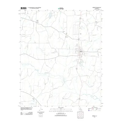
2012 Map of Bernice
USGS Topo · Published 2012About this map
Bernice serves as the central hub of this North Louisiana landscape, where a dense grid of streets meets the winding path of Middle Fork Bayou D'Arbonne. This 2012 survey illustrates a region defined by its timber and energy resources, with the Lynn Creek Gas Field and Mount Olive Oil and Gas Field appearing alongside smaller settlements like Weldon and Hunt. The map is particularly useful for genealogical research, documenting numerous family and community burial grounds such as the Alabama-Weldon Cemetery, Tubbs Cemetery, and Jones Cemetery. Rural life is etched into the terrain through a network of parish roads, including Double Bridges Road and Parish Line Road, which connect isolated churches like Harmony Chapel to the larger town center. The drainage patterns of Cane Creek and Bull Creek underscore the importance of the bayou's tributaries in shaping the local geography.
Find a feature on this map
97 named features on this map. Tap any name to fly to it.
Don’t see what you’re looking for? This feature index may not catch every label — zoom into the map to look around manually.
Map Details
Editions of this 2012 Bernice Map
This is the sole edition of this map. No revisions or reprints were ever made.
Other maps of this area

1950 · Ruston
USGS Topo · 1:62,500

1950 · Arcadia
USGS Topo · 1:62,500

1951 · Arcadia
USGS Topo · 1:62,500

1951 · Ruston
USGS Topo · 1:62,500

1951 · Summerfield
USGS Topo · 1:62,500

1951 · Bernice
USGS Topo · 1:62,500

1955 · Shreveport
USGS Topo · 1:250,000

1956 · Shreveport
USGS Topo · 1:250,000

1984 · Shreveport
USGS Topo · 1:250,000

1985 · Monroe North
USGS Topo · 1:100,000