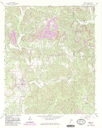
1967 Map of Berry
USGS Topo · Published 1983About this map
Berry sits at the junction of the Southern railroad and several local creek drainages, serving as a focal point for this portion of the Fayette and Walker County border. The landscape is defined by the industrial presence of Strip Mine operations and numerous Mines that mark the terrain between Pea Ridge and Frost Hill. Extensive woodland covers much of the area, including the Wolf Creek Wildlife Management Area in the northern reaches. For genealogists, the map is a dense record of rural community life, featuring a high concentration of country churches and family burial grounds such as Bethabara Ch, Old Salem Ch, and Tabernacle Cem. Small settlements like Alta and Boley Springs are connected by a network of unimproved roads and light-duty paths that follow the winding courses of Cane Creek and Cedar Creek.
Find a feature on this map
46 named features on this map. Tap any name to fly to it.
Don’t see what you’re looking for? This feature index may not catch every label — zoom into the map to look around manually.
Map Details
Editions of this 1967 Berry Map
4 editions found
Other maps of this area

1893 · Jasper
USGS Topo · 1:125,000

1949 · Townley
USGS Topo · 1:24,000

1949 · Oakman
USGS Topo · 1:24,000

1949 · Wiley
USGS Topo · 1:24,000

1951 · Oakman
USGS Topo · 1:24,000

1951 · Wiley
USGS Topo · 1:24,000

1951 · Townley
USGS Topo · 1:24,000

1953 · Birmingham
USGS Topo · 1:250,000

1956 · Birmingham
USGS Topo · 1:250,000

1957 · Birmingham
USGS Topo · 1:250,000