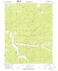
1978 Map of Berryman
USGS Topo · Published 1979About this map
Berryman serves as a central point in this part of the Mark Twain National Forest, where the settlement and land use are defined by the winding paths of Courtois Creek and Lost Creek. The map documents a landscape of public recreation and deep-rooted local history, evidenced by a network of camps including Brazil Creek Campground and the Edward Beecher Recreation Area. Genealogists will find significant value in the distribution of family-named burial sites and landmarks like Courtois Cem, Dobkins Cem, and Criswell Cem, along with Oak Grove Ch. The terrain is characterized by prominent ridges such as Shirley Ridge and Cedar Ridge, which separate the numerous hollows that dominate the local topography. This 1970s survey captures the area at a time when traditional community anchors like rural churches and cemeteries remained preserved within the bounds of a managed national forest.
Find a feature on this map
32 named features on this map. Tap any name to fly to it.
Don’t see what you’re looking for? This feature index may not catch every label — zoom into the map to look around manually.
Map Details
Editions of this 1978 Berryman Map
4 editions found
Other maps of this area

1901 · De Soto
USGS Topo · 1:125,000

1903 · Sullivan
USGS Topo · 1:125,000

1906 · Potosi
USGS Topo · 1:62,500

1943 · Berryman
USGS Topo · 1:62,500

1945 · Berryman
USGS Topo · 1:62,500

1946 · Richwoods
USGS Topo · 1:62,500

1947 · Sullivan
USGS Topo · 1:62,500

1948 · Richwoods
USGS Topo · 1:62,500

1949 · Saint Louis
USGS Topo · 1:250,000

1949 · Sullivan
USGS Topo · 1:62,500