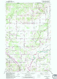
1952 Map of Bertrand Creek
USGS Topo · Published 1994About this map
Nooksack River meanders across the southern portion of this borderland terrain, anchoring a landscape where the agricultural grid of northern Washington meets the international boundary at the Canada United States line. The map illustrates a developed rural corridor in the mid-20th century, characterized by its network of local roads such as Badger Road and Street Road. The area is notably dotted with community institutions like the Sunrise Church and the Enterprise Cem, reflecting the deep roots of the local population. Near the river, modern infrastructure appears in the form of a Filtration Plant and the Bellingham Omni Radio Range Sta, while recreational and natural spaces like Berthusen Memorial Park and the small Willey Lake provide insight into the region's land use during this period of growth.
Find a feature on this map
43 named features on this map. Tap any name to fly to it.
Don’t see what you’re looking for? This feature index may not catch every label — zoom into the map to look around manually.
Map Details
Editions of this 1952 Bertrand Creek Map
3 editions found
Other maps of this area

1906 · Sumas
USGS Topo · 1:62,500

1907 · Blaine
USGS Topo · 1:62,500

1908 · Sumas
USGS Topo · 1:62,500

1952 · Bertrand Creek
USGS Topo · 1:24,000

1952 · Lynden
USGS Topo · 1:24,000

1952 · Ferndale
USGS Topo · 1:24,000

1952 · Lummi Bay
USGS Topo · 1:24,000

1952 · Blaine
USGS Topo · 1:24,000

1952 · Blaine
USGS Topo · 1:62,500

1954 · Bellingham North
USGS Topo · 1:24,000