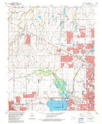
1986 Map of Bethany
USGS Topo · Published 1987About this map
The Lake Overholser reservoir and the sprawling Stinchcomb Wildlife Refuge along the North Canadian River anchor the landscape of this mid-1980s suburban Oklahoma study. This edition captures the rapid expansion of Oklahoma City as it surrounds independent municipalities like Bethany, Warr Acres, and the eastern edge of Yukon. The area is a hub for education and regional transit, featuring Bethany College, the Francis Tuttle Voc-Tech Sch, and the busy Wiley Post Airport. Institutional landmarks such as the St Francis DeSales Seminary and several large memorial parks, including Chapel Hill Memorial Gardens Cem, suggest a maturing community infrastructure. Commercial and residential growth is tightly tied to the Northwest Expressway and the Oklahoma-Kansas-Texas railroad line, while pockets of oil production remain visible in the active Gas Field and scattered oil wells across the terrain.
Find a feature on this map
60 named features on this map. Tap any name to fly to it.
Don’t see what you’re looking for? This feature index may not catch every label — zoom into the map to look around manually.
Map Details
Editions of this 1986 Bethany Map
This is the sole edition of this map. No revisions or reprints were ever made.
Other maps of this area

1892 · Kingfisher
USGS Topo · 1:125,000

1893 · Oklahoma City
USGS Topo · 1:62,500

1893 · Minco
USGS Topo · 1:62,500

1895 · Kingfisher
USGS Topo · 1:125,000

1904 · Chickasha
USGS Topo · 1:125,000

1951 · Britton
USGS Topo · 1:24,000

1954 · Oklahoma City
USGS Topo · 1:250,000

1956 · Oklahoma City
USGS Topo · 1:24,000

1956 · Oklahoma City
USGS Topo · 1:62,500

1957 · Oklahoma City
USGS Topo · 1:250,000