
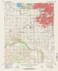
1956 Map of Oklahoma City
USGS Topo · Published 1957About this map
Oklahoma City's mid-century expansion is charted here alongside the winding course of the Canadian River. The urban core is dense with civic and educational landmarks, ranging from the State Capitol and Oklahoma City University to an extensive network of neighborhood schools like Franklin Sch and Sacred Heart Sch. To the west, Lake Overholser and the Council Grove area represent the city's interface with the surrounding prairies.
Find a feature on this map
110 named features on this map. Tap any name to fly to it.
Don’t see what you’re looking for? This feature index may not catch every label — zoom into the map to look around manually.
Map Details
Editions of this 1956 Oklahoma City Map
2 editions found
Other maps of this area

1892 · Moore
USGS Topo · 1:62,500

1892 · Edmond
USGS Topo · 1:62,500

1892 · Kingfisher
USGS Topo · 1:125,000

1893 · Norman
USGS Topo · 1:62,500

1893 · Oklahoma City
USGS Topo · 1:62,500
1893 · Minco
USGS Topo · 1:62,500

1895 · Kingfisher
USGS Topo · 1:125,000

1898 · Purcell
USGS Topo · 1:125,000

1904 · Chickasha
USGS Topo · 1:125,000

1925 · Norman NO 2
USGS Topo · 1:24,000