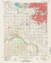
1956 Map of Oklahoma City
USGS Topo · Published 1984About this map
Oklahoma City stands at the heart of this mid-1950s survey, showing a metropolis expanding rapidly toward its neighbors. The dense urban grid of the city, complete with numerous educational landmarks like NW Classen High Sch and Capitol Hill High Sch, transitions into the planned residential growth of Bethany and Council. To the west, Lake Overholser and the surrounding Council Grove terrain provide a hydrologic boundary, while the Canadian River winds across the southern reaches of the map. This era is defined by a heavy reliance on the rail network, featuring the Chicago Rock Island and Pacific and the St Louis San Francisco lines. The southern rural sections, such as Mustang and Wheatland, remain largely agricultural, dotted with country institutions like Antioch Ch and Snow Hill Ch, before the suburban sprawl fully reached these outlying communities.
Find a feature on this map
87 named features on this map. Tap any name to fly to it.
Don’t see what you’re looking for? This feature index may not catch every label — zoom into the map to look around manually.
Map Details
Editions of this 1956 Oklahoma City Map
2 editions found

Other maps of this area

1892 · Moore
USGS Topo · 1:62,500

1892 · Edmond
USGS Topo · 1:62,500

1892 · Kingfisher
USGS Topo · 1:125,000

1893 · Norman
USGS Topo · 1:62,500

1893 · Oklahoma City
USGS Topo · 1:62,500

1893 · Minco
USGS Topo · 1:62,500

1895 · Kingfisher
USGS Topo · 1:125,000

1898 · Purcell
USGS Topo · 1:125,000

1904 · Chickasha
USGS Topo · 1:125,000

1925 · Norman NO 2
USGS Topo · 1:24,000