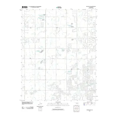
2009 Map of Bethany NE
USGS Topo · Published 2009About this map
Deer Creek and its many tributaries, including Bloody Rush Creek and Bluff Creek, define the drainage patterns of this transitioning Oklahoma landscape north of Oklahoma City. By 2009, the area shows a distinct shift from agricultural roots to modern suburban development, evidenced by the dense residential grids of Napa Valley Rd and Saratoga Xing contrasted against large reservoir tracts like Oknoname 16 Reservoir. Local history is anchored by the Christner Cemetery and Whistler Cemetery, while the Higbee Community Hall serves as a reminder of earlier rural community life. Small private aviation hubs like Wakefield Strip and the Northwest Edmond Airport emphasize the region's low-density, wide-open layout at the turn of the decade. The map also documents numerous earthen works, including the J-M Ranch Dam and Deer Creek Farms Dam, which have altered the natural flow of these prairie streams.
Find a feature on this map
57 named features on this map. Tap any name to fly to it.
Don’t see what you’re looking for? This feature index may not catch every label — zoom into the map to look around manually.
Map Details
Editions of this 2009 Bethany NE Map
This is the sole edition of this map. No revisions or reprints were ever made.
Other maps of this area

1892 · Guthrie
USGS Topo · 1:62,500

1892 · Edmond
USGS Topo · 1:62,500

1892 · Kingfisher
USGS Topo · 1:125,000

1895 · Kingfisher
USGS Topo · 1:125,000

1935 · Spencer
USGS Topo · 1:24,000

1935 · Edmond
USGS Topo · 1:48,000

1940 · Edmond
USGS Topo · 1:62,500

1951 · Britton
USGS Topo · 1:24,000

1954 · Oklahoma City
USGS Topo · 1:250,000
1956 · Spencer
USGS Topo · 1:24,000