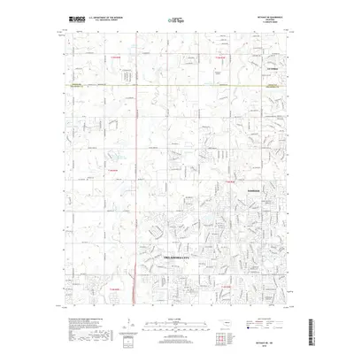
2018 Map of Bethany NE
USGS Topo · Published 2018About this map
Oklahoma City and Edmond expand toward their shared borders in this 2018 survey, reflecting the suburban transformation along the Oklahoma and Logan County line. The landscape is defined by the headwaters of numerous waterways, including Deer Creek and Bluff Creek, which are interspersed with residential developments and reservoirs like 16 Reservoir and Deer Creek Farms Lake. While modern road networks such as Mac Arthur Blvd and Waterloo Rd dominate the grid, older landmarks offer a connection to the area's earlier rural history. Local genealogists and historians will find the Christner Cem and Whisler Cem preserved amidst the increasing density. The northern portion of the map captures the southern outskirts of Guthrie, showing how the traditional agrarian sections of the territory are being integrated into the metropolitan corridor while maintaining natural drainage systems like Deep Creek and Bloody Rush Creek.
Find a feature on this map
52 named features on this map. Tap any name to fly to it.
Don’t see what you’re looking for? This feature index may not catch every label — zoom into the map to look around manually.
Map Details
Editions of this 2018 Bethany NE Map
This is the sole edition of this map. No revisions or reprints were ever made.
Other maps of this area

1892 · Guthrie
USGS Topo · 1:62,500

1892 · Edmond
USGS Topo · 1:62,500

1892 · Kingfisher
USGS Topo · 1:125,000

1895 · Kingfisher
USGS Topo · 1:125,000

1935 · Spencer
USGS Topo · 1:24,000

1935 · Edmond
USGS Topo · 1:48,000

1940 · Edmond
USGS Topo · 1:62,500

1951 · Britton
USGS Topo · 1:24,000

1954 · Oklahoma City
USGS Topo · 1:250,000
1956 · Spencer
USGS Topo · 1:24,000