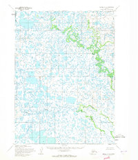
1954 Map of Bethel A-8
USGS Topo · Published 1965About this map
The Eek River meanders across this vast delta landscape in the Bethel region, showing the intricate network of wetlands and channels as they existed in the early 1950s. Surveyed by the Army Map Service and published by the Geological Survey, this sheet provides a detailed view of the water-dominated terrain before modern shifts in the riverbanks. The winding path of the Uyaklik River and the course of Kuskokwak Creek define the hydrology of this unsurveyed area, where land lines were predetermined by the Bureau of Land Management rather than marked on the ground. These waterways were essential corridors for travel and subsistence in this part of the Seward Meridian, long before significant infrastructure reached the region.
Find a feature on this map
4 named features on this map. Tap any name to fly to it.
Don’t see what you’re looking for? This feature index may not catch every label — zoom into the map to look around manually.
Map Details
Editions of this 1954 Bethel A-8 Map
2 editions found
Other maps of this area

1950 · Bethel
USGS Topo · 1:250,000

1951 · Kuskokwim Bay
USGS Topo · 1:250,000

1951 · Goodnews
USGS Topo · 1:250,000

1951 · Baird Inlet
USGS Topo · 1:250,000

1954 · Bethel B-7
USGS Topo · 1:63,360

1954 · Bethel B-8
USGS Topo · 1:63,360

1954 · Bethel A-7
USGS Topo · 1:63,360

1954 · Baird Inlet
USGS Topo · 1:250,000

1954 · Kuskokwim Bay
USGS Topo · 1:250,000

1954 · Goodnews D-7
USGS Topo · 1:63,360