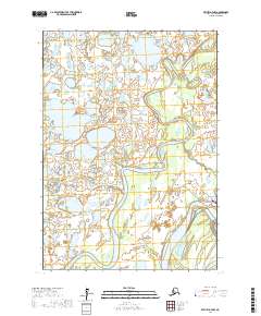
2017 Map of Bethel D-7 NW
USGS Topo · Published 2017About this map
The Gweek River dominates this landscape, meandering through a complex network of wetlands and tundra in the Bethel Census Area. The river's serpentine path through the northern and central sections of the map illustrates the dynamic hydrology of the region before it approaches its confluence with the Kuskokwim River in the southeast. This 2017 survey by the U.S. Geological Survey highlights the limited but critical terrestrial infrastructure in this environment, specifically the New Ariachak Airport Access Road and Main Street. These features indicate the proximity of local settlement and the importance of air and water transport in a region where the land is defined more by its shifting waterways than by fixed roads.
Find a feature on this map
10 named features on this map. Tap any name to fly to it.
Don’t see what you’re looking for? This feature index may not catch every label — zoom into the map to look around manually.
Map Details
Editions of this 2017 Bethel D-7 NW Map
This is the sole edition of this map. No revisions or reprints were ever made.
Other maps of this area

1947 · Russian Mission
USGS Topo · 1:250,000

1950 · Russian Mission
USGS Topo · 1:250,000

1950 · Bethel
USGS Topo · 1:250,000

1954 · Russian Mission A-8
USGS Topo · 1:63,360
1954 · Russian Mission A-7
USGS Topo · 1:63,360

1954 · Bethel D-8
USGS Topo · 1:63,360

1954 · Bethel D-7
USGS Topo · 1:63,360

1980 · Russian Mission
USGS Topo · 1:250,000

1980 · Bethel
USGS Topo · 1:250,000
2017 · Bethel D-8 SE
USGS Topo · 1:25,000