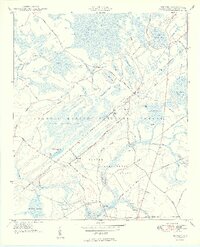
1950 Map of Bethera
USGS Topo · Published 1950About this map
Bethera and the surrounding Berkeley County wetlands are documented here in the years following World War II, showing a landscape defined by the Seaboard Air Line railroad and the timber-rich tracts of the Francis Marion National Forest. The map captures a transition in land use, from established settlements like Limerick and Kensington to the research-driven acreage of the Santee Experimental Forest. The distinctive Carolina bays, such as Walleye Bay, Little Hellhole Bay, and Boggy Head Bay, dominate the topography, illustrating the complex drainage patterns of Peters Swamp and Jericho Swamp. Social and economic life is marked by local landmarks like Berea Ch, Bethel Ch Cem, and the Herberta Siding, while a Landing Strip near Witherbee highlights the area's utility for forest management and transportation during this era.
Find a feature on this map
75 named features on this map. Tap any name to fly to it.
Don’t see what you’re looking for? This feature index may not catch every label — zoom into the map to look around manually.
Map Details
Editions of this 1950 Bethera Map
2 editions found
Other maps of this area

1919 · Cordesville
USGS Topo · 1:48,000

1943 · Shulerville
USGS Topo · 1:24,000

1943 · Jamestown
USGS Topo · 1:24,000

1943 · Ocean Bay
USGS Topo · 1:24,000

1943 · Bonneau
USGS Topo · 1:62,500

1948 · Cordesville
USGS Topo · 1:24,000

1948 · Bethera
USGS Topo · 1:24,000
1949 · Cordesville
USGS Topo · 1:24,000

1949 · Georgetown
USGS Topo · 1:250,000
1950 · Huger
USGS Topo · 1:24,000