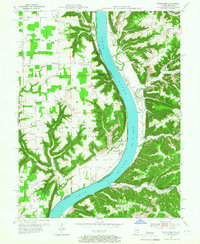
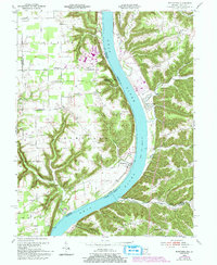
1953 Map of Bethlehem
USGS Topo · Published 1972About this map
The Ohio River carves a deep, winding channel through this mid-century landscape, separating the wooded bluffs of Trimble and Oldham counties in Kentucky from the agricultural uplands of Clark and Jefferson counties in Indiana. Along the Indiana bank, the settlement of Bethlehem sits at a prominent river bend, supported by a network of rural churches and cemeteries that speak to the area’s deep-rooted community ties. Elizabeth Ch and Bethel Ch anchor the northern reaches near Otto and Marble Hill, while the rugged drainage systems of Camp Creek and Little Camp Creek define the western topography. Across the water, the Kentucky side is characterized by narrow hollows like Doolittle Hollow and Abbott Hollow, with small landings such as Wises Landing providing historical points of river access. This period captures the region's transition into the 1950s, preserving the location of family-named landmarks like the Mahoney Cem and Turner Cem before significant modern development.
Find a feature on this map
44 named features on this map. Tap any name to fly to it.
Don’t see what you’re looking for? This feature index may not catch every label — zoom into the map to look around manually.
Map Details
Editions of this 1953 Bethlehem Map
6 editions found

Other maps of this area

1905 · Prospect
USGS Topo · 1:62,500

1912 · Prospect
USGS Topo · 1:62,500

1932 · La Grange
USGS Topo · 1:62,500

1938 · Owen
USGS Topo · 1:24,000

1939 · Bethlehem
USGS Topo · 1:24,000

1939 · Madison West
USGS Topo · 1:24,000

1948 · Bethlehem
USGS Topo · 1:24,000

1948 · Madison West
USGS Topo · 1:24,000

1948 · Owen
USGS Topo · 1:24,000

1953 · Madison West
USGS Topo · 1:24,000