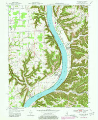
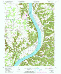
1953 Map of Bethlehem
USGS Topo · Published 1981About this map
The Ohio River carves a deep valley through the borderlands of Indiana and Kentucky, anchoring the small riverfront community of Bethlehem. On the Indiana side, the landscape is defined by the winding paths of Big Saluda Creek and Camp Creek, which cut through the limestone terrain toward the river. This mid-century survey captures a rural environment in transition, noting infrastructure projects "under construction" near Marble Hill. Further inland, family names and community foundations are preserved through several landmarks, including Elizabeth Ch and the Turner Cem. Across the water in Kentucky, the terrain becomes increasingly complex around Rodgers Ridge and the deep cuts of Barebone Creek. The map documents a network of rural schoolhouse branches and hilltop settlements like Wises Landing and Mt Pleasant, providing a clear view of the dispersed residential and agricultural patterns that shaped the river valley before more modern development reached these ridges.
Find a feature on this map
49 named features on this map. Tap any name to fly to it.
Don’t see what you’re looking for? This feature index may not catch every label — zoom into the map to look around manually.
Map Details
Editions of this 1953 Bethlehem Map
6 editions found

Other maps of this area

1905 · Prospect
USGS Topo · 1:62,500

1912 · Prospect
USGS Topo · 1:62,500

1932 · La Grange
USGS Topo · 1:62,500

1938 · Owen
USGS Topo · 1:24,000

1939 · Bethlehem
USGS Topo · 1:24,000

1939 · Madison West
USGS Topo · 1:24,000

1948 · Bethlehem
USGS Topo · 1:24,000

1948 · Madison West
USGS Topo · 1:24,000

1948 · Owen
USGS Topo · 1:24,000

1953 · Madison West
USGS Topo · 1:24,000