
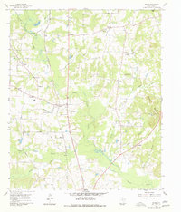
1960 Map of Bettie
USGS Topo · Published 1962About this map
Bettie sits at the center of this rural Upshur County landscape, serving as a hub for the St Louis Southwestern RR and surrounding agricultural communities in the early 1960s. The map illustrates a dense network of local landmarks, from the Union Ridge Community Center in the north to the Cherokee Missionary Ch in the south. The terrain is defined by the winding course of Little Cypress Creek and its many tributaries, such as Hefner Branch and Poor Creek, which drain the low-lying areas between Union Ridge and the Barnwell Mountains. One notable modern addition to the traditional landscape of country churches and cemeteries is the Drag Strip located just south of Bettie, contrasting with the historic Cherokee Trace that passes through the region. This survey captures a specific moment when family-named landmarks like Smith Siding and Blasingame still anchored the local geography.
Find a feature on this map
42 named features on this map. Tap any name to fly to it.
Don’t see what you’re looking for? This feature index may not catch every label — zoom into the map to look around manually.
Map Details
Editions of this 1960 Bettie Map
2 editions found
Other maps of this area

1956 · Tyler
USGS Topo · 1:250,000

1960 · Pritchett
USGS Topo · 1:24,000

1960 · Gilmer
USGS Topo · 1:24,000

1960 · Thomas
USGS Topo · 1:24,000

1960 · Leesburg
USGS Topo · 1:24,000

1960 · Coffeeville
USGS Topo · 1:24,000

1960 · Glenwood
USGS Topo · 1:24,000

1960 · La Fayette
USGS Topo · 1:24,000

1960 · Pittsburg
USGS Topo · 1:24,000

1984 · Tyler
USGS Topo · 1:250,000