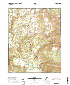
2017 Map of Bettles A-1 SE
USGS Topo · Published 2017About this map
The Alaska Pipeline and the Dalton Highway serve as the primary north-south corridor through this interior Alaskan wilderness, following a path that cuts across the remote landscape. This 2017 survey illustrates the complex relationship between modern industrial infrastructure and the natural environment in the Yukon-Koyukuk Census Area. The southern portion of the map is dominated by the winding course of the Ray River, which creates a network of wetlands and shifting channels as it flows westward. To the east, the Fort Hamlin Hills rise above the surrounding basin, providing a distinct topographic boundary. This map is particularly useful for understanding the scale of the Trans-Alaska Pipeline System and its accompanying service road as they navigate the vast unpopulated stretches of the subarctic north.
Find a feature on this map
8 named features on this map. Tap any name to fly to it.
Don’t see what you’re looking for? This feature index may not catch every label — zoom into the map to look around manually.
Map Details
Editions of this 2017 Bettles A-1 SE Map
This is the sole edition of this map. No revisions or reprints were ever made.
Other maps of this area

1945 · Livengood
USGS Topo · 1:250,000

1951 · Bettles
USGS Topo · 1:250,000

1951 · Tanana
USGS Topo · 1:250,000

1951 · Livengood
USGS Topo · 1:250,000

1951 · Beaver
USGS Topo · 1:250,000

1956 · Bettles
USGS Topo · 1:250,000

1956 · Beaver
USGS Topo · 1:250,000

1956 · Livengood D-6
USGS Topo · 1:63,360

1956 · Tanana D-1
USGS Topo · 1:63,360

1956 · Livengood
USGS Topo · 1:250,000