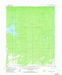
1970 Map of Bettles A-6
USGS Topo · Published 1973About this map
Lake Todatonten dominates the western landscape of this 1970 interior Alaska survey, a significant water body in an area defined by complex drainage and permafrost features. The map illustrates the presence of multiple Pingos and a single Pingo, which are characteristic ice-cored mounds found in arctic and subarctic environments. Navigation through this remote terrain is marked by a Winter Trail that skirts the eastern shore of the lake, indicating the seasonal nature of travel in the region during the mid-20th century. To the south and east, the drainage systems of Hogazzithethno Creek and Kodatna Creek carve through the land, showing the intricate hydrology of the Yukon-Koyukuk region before significant modern development. The map was produced using photogrammetric methods from 1970 aerial photography, capturing the land's surface as predetermined by the Bureau of Land Management.
Find a feature on this map
6 named features on this map. Tap any name to fly to it.
Don’t see what you’re looking for? This feature index may not catch every label — zoom into the map to look around manually.
Map Details
Editions of this 1970 Bettles A-6 Map
This is the sole edition of this map. No revisions or reprints were ever made.
Other maps of this area

1951 · Hughes
USGS Topo · 1:250,000

1951 · Melozitna
USGS Topo · 1:250,000

1951 · Bettles
USGS Topo · 1:250,000

1951 · Tanana
USGS Topo · 1:250,000

1952 · Melozitna D-1
USGS Topo · 1:63,360

1955 · Hughes A-1
USGS Topo · 1:63,360

1956 · Hughes
USGS Topo · 1:250,000

1956 · Bettles
USGS Topo · 1:250,000

1956 · Tanana D-6
USGS Topo · 1:63,360
1956 · Tanana D-5
USGS Topo · 1:63,360