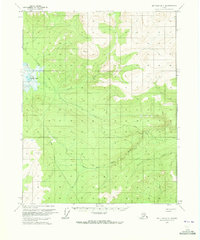
1970 Map of Bettles B-1
USGS Topo · Published 1973About this map
Olsons Lake and the winding course of the Kanuti River dominate this interior Alaskan landscape as it was documented in 1970. The terrain is defined by a remote network of seasonal access, where a Winter Road and Winter Trail provided essential passage through the subarctic wilderness before more permanent infrastructure reached the region. This survey captures the drainage patterns of the West Fork Dall River and Coal Creek, reflecting the importance of water and seasonal pathways in navigating the Fairbanks Meridian. These features represent the primary transit corridors for the era, etched across a landscape where traditional land lines remained largely unsurveyed and unmarked by the Bureau of Land Management.
Find a feature on this map
6 named features on this map. Tap any name to fly to it.
Don’t see what you’re looking for? This feature index may not catch every label — zoom into the map to look around manually.
Map Details
Editions of this 1970 Bettles B-1 Map
2 editions found
Other maps of this area

1951 · Bettles
USGS Topo · 1:250,000

1951 · Beaver
USGS Topo · 1:250,000

1956 · Bettles
USGS Topo · 1:250,000

1956 · Beaver
USGS Topo · 1:250,000

1964 · Beaver
USGS Topo · 1:250,000

1970 · Bettles B-2
USGS Topo · 1:63,360
1970 · Beaver C-6
USGS Topo · 1:63,360

1970 · Beaver B-6
USGS Topo · 1:63,360
1970 · Bettles C-1
USGS Topo · 1:63,360

1970 · Bettles C-2
USGS Topo · 1:63,360