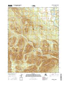
2016 Map of Bettles D-4 NW
USGS Topo · Published 2016About this map
The Alatna Hills dominate the western half of this interior Alaskan landscape, providing a high-relief backdrop to the river systems that define the region's geography. Flowing through the northeast corner, the John River is a central hydrological feature, accompanied by nearby Goose Slough. The terrain transitions from these prominent elevations toward lower-lying wetlands and smaller water bodies like Pitchuk Lake. To the south, Lookout Mtn stands as a distinct landmark above the drainage of Jane Cr. This 2016 survey captures the area's natural state within the Yukon-Koyukuk region, illustrating the complex topographic contours and the isolation of these northern ranges where the watercourses serve as the primary geographical guides.
Find a feature on this map
10 named features on this map. Tap any name to fly to it.
Don’t see what you’re looking for? This feature index may not catch every label — zoom into the map to look around manually.
Map Details
Editions of this 2016 Bettles D-4 NW Map
This is the sole edition of this map. No revisions or reprints were ever made.
Other maps of this area

1951 · Bettles
USGS Topo · 1:250,000

1951 · Wiseman
USGS Topo · 1:250,000

1956 · Bettles
USGS Topo · 1:250,000

1956 · Wiseman
USGS Topo · 1:250,000

1964 · Wiseman
USGS Topo · 1:250,000

1970 · Bettles D-4
USGS Topo · 1:63,360

1970 · Wiseman A-4
USGS Topo · 1:63,360

1970 · Wiseman A-5
USGS Topo · 1:63,360
1970 · Bettles D-5
USGS Topo · 1:63,360
2016 · Wiseman A-5 SE
USGS Topo · 1:25,000