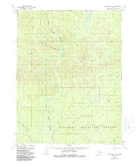
1970 Map of Bettles D-5
USGS Topo · Published 1988About this map
The Alatna Hills dominate the northern terrain of this quadrangle, giving way to the sprawling wetlands of the Kanuti National Wildlife Refuge to the south. This 1970 survey, annotated just before the formal establishment of the refuge boundaries, illustrates a remote subarctic landscape defined by complex hydrological systems. The East Fork Henshaw (Sozhekla) Creek and West Fork Henshaw (Sozhekla) Creek snake through the interior, their braided patterns typical of the Kanuti region's interior drainage. A lone Winter Trail in the southeast corner provides the only evidence of overland transportation in this roadless wilderness. Historical hydrologic names like Fickett Creek point to early exploratory efforts in the Yukon-Koyukuk region, while the dual labeling of the Henshaw branches preserves the indigenous Sozhekla nomenclature.
Find a feature on this map
13 named features on this map. Tap any name to fly to it.
Don’t see what you’re looking for? This feature index may not catch every label — zoom into the map to look around manually.
Map Details
Editions of this 1970 Bettles D-5 Map
2 editions found
Other maps of this area

1951 · Bettles
USGS Topo · 1:250,000

1951 · Wiseman
USGS Topo · 1:250,000

1956 · Bettles
USGS Topo · 1:250,000

1956 · Wiseman
USGS Topo · 1:250,000

1964 · Wiseman
USGS Topo · 1:250,000

1970 · Bettles D-4
USGS Topo · 1:63,360
1970 · Wiseman A-6
USGS Topo · 1:63,360

1970 · Wiseman A-4
USGS Topo · 1:63,360

1970 · Bettles C-4
USGS Topo · 1:63,360
1970 · Bettles D-6
USGS Topo · 1:63,360