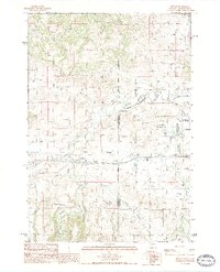
1984 Map of Beulah
USGS Topo · Published 1984About this map
Beulah serves as the primary settlement on this 1984 survey, situated at the confluence of several vital watercourses near the Wyoming and South Dakota border. The landscape is defined by the winding path of Redwater Creek and its southern fork, which transition from the steep, dissected terrain of The Brakes in the northwest to broader valley floors. This area highlights a carefully managed water landscape, evidenced by infrastructure like Thompson Ditch and a Fish Hatchery located near the spring-fed waters of Crow Creek. A small local cemetery, labeled simply Cem, provides a point of interest for genealogists tracing early residents of this borderland community.
Find a feature on this map
30 named features on this map. Tap any name to fly to it.
Don’t see what you’re looking for? This feature index may not catch every label — zoom into the map to look around manually.
Map Details
Editions of this 1984 Beulah Map
2 editions found
Other maps of this area

1894 · Deadwood
USGS Topo · 1:125,000

1898 · Sundance
USGS Topo · 1:125,000

1900 · Spearfish
USGS Topo · 1:62,500

1901 · Deadwood
USGS Topo · 1:125,000

1901 · Aladdin
USGS Topo · 1:125,000

1902 · Sundance
USGS Topo · 1:125,000

1903 · Aladdin
USGS Topo · 1:125,000

1907 · Belle Fourche
USGS Topo · 1:125,000

1907 · Redwater
USGS Topo · 1:62,500

1915 · Spearfish
USGS Topo · 1:62,500