
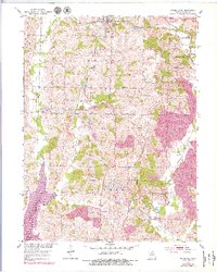
1953 Map of Bevier South
USGS Topo · Published 1955About this map
The Bevier and Southern railroad winds southward from Bevier, serving as a vital artery for the coal mining operations that define this section of Macon County. Extensive strip mines and mine dumps dominate the landscape between Keota and Ardmore, illustrating the intense industrial extraction occurring in the mid-1950s. The landscape is a complex network of hydrological forks, including the East Fork, North Fork, and Middle Fork Chariton River, which carve through the terrain and influence the placement of early settlements. Rural life persists alongside the mines, evidenced by scattered local institutions like Thurman Sch, Antioch Ch, and New Salem Ch. The southern edge of the map shows the transition toward College Mound, where mining activity appears as under construction, signaling the continued expansion of the local coal industry into new territory.
Find a feature on this map
35 named features on this map. Tap any name to fly to it.
Don’t see what you’re looking for? This feature index may not catch every label — zoom into the map to look around manually.
Map Details
Editions of this 1953 Bevier South Map
2 editions found
Other maps of this area

1908 · Atlanta
USGS Topo · 1:62,500

1908 · Macon
USGS Topo · 1:62,500

1910 · Macon
USGS Topo · 1:62,500

1937 · Elmer
USGS Topo · 1:48,000

1942 · Elmer
USGS Topo · 1:62,500

1953 · Moberly
USGS Topo · 1:250,000

1953 · College Mound
USGS Topo · 1:24,000

1953 · Prairie Hill
USGS Topo · 1:24,000

1953 · Lagonda
USGS Topo · 1:24,000

1954 · Moberly
USGS Topo · 1:250,000