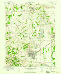
1958 Map of Bicknell
USGS Topo · Published 1960About this map
The Bicknell town grid and its surrounding coal-mining operations dominate this late 1950s landscape in Knox County. Numerous strip mines and an extensive network of drainage channels, including Miller Ditch and Purdy-Marsh Ditch, reflect a terrain heavily altered by resource extraction and agricultural reclamation. In the town itself, local life is anchored by landmarks such as the Hooper Athletic Field and the Bicknell Country Club, while the Pennsylvania line provides the essential rail connection for the region's industrial output.
Find a feature on this map
29 named features on this map. Tap any name to fly to it.
Don’t see what you’re looking for? This feature index may not catch every label — zoom into the map to look around manually.
Map Details
Editions of this 1958 Bicknell Map
3 editions found
Other maps of this area

1942 · Fritchton
USGS Topo · 1:24,000

1943 · Carlisle
USGS Topo · 1:24,000

1943 · Oaktown
USGS Topo · 1:24,000

1943 · Sandborn
USGS Topo · 1:24,000

1943 · Bicknell
USGS Topo · 1:24,000

1943 · Plainville
USGS Topo · 1:24,000

1944 · Bucktown
USGS Topo · 1:24,000

1944 · Fritchton
USGS Topo · 1:24,000

1944 · Washington
USGS Topo · 1:24,000

1944 · Wheatland
USGS Topo · 1:24,000